
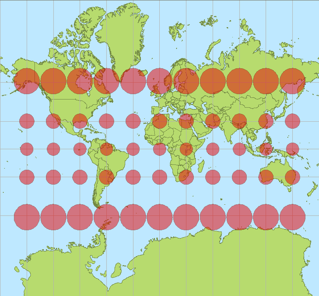
Mercator projection. Red circles show the deformation.
Since the world is (almost) spherical and the paper is not, when we draw bidimensional maps we have to project the sphere on the paper. There are many ways to do it. One of the most populars is the Mercator projection (above). But projecting spheres have a problem with deformations, and as is shown in the map, austral and septentrional zones grow with this kind.
We use the Miller projection at Público.

Miller projection. Stil not exact, but somehow a little less deformated.
But there is who complaints because of the 'unfair' of these projections. They think that get the north countries bigger doesn't help to the south countries, poorer. They think all this doesn't help the cause of equality. They think the best way to represent the spherical world is Peters projection.

Peters projection. Horizontal deformation compensated by vertical deformation.
A chapter of 'The West Wing'treated the use of this map.
But the polmeic doesn't end here. In Spain, having Canary Island in the map is a problem. They're far from the peninsula, so we get them in a little box on a corner to have them near.

But the real ubication is the shown on this map. Practical needs.

On Público we have a daily section called Cartas con Respuesta (Letters with answer) on which Rafa Reig answer letters written to the newspaper. Today, a reader make his complaints on having Canary Islands ona box in the weather map, instead of its actual ubication (having them in a box is something made on almost every single map of Spain). Our particular spanish Map of Peters.
It would be reasonable that, on the weather map, Canay Islands were placed where they really are, in front of Sahara. It's not logic that, adding to the long distance thay are form Spain, we have a geospacial desubication.
The answer deserves the reading because of its ironic point of view. (This is just an extract, for the whole text, in spanish, click here)
Now we face such serious situation, what could we do? First of all, complain, as you dare to do with braveness and fearless. Second, act forcefulness. I've made a roposal to Publico's leaders to have the weather map as a world map. How people would know where Canary Islands are without the reference of the poles? Without knowing the size difference between Canary Islands and Madeira? Isn't a try to lie, manipulate and antidemocratic? The problem is, as you already know, that Earth is spherical and maps are bidimimensional. Representing a threedimensional objetc just using two of its dimensions is never an innocent act: try to deflate a ball and stretch it on a table, and you'll see that not an easy work. Which projection should we use in order to stop lying to readers? Mercator, Winkel-Tripel or Peters? Which one would be the fairest with the situation and the real size of Canary Islands
Thanks for the information, Gonzalo.
No comments:
Post a Comment